Reading the Sky: A Reluctant Taxonomy of Clouds

I have been staring at clouds for the better part of four decades, and I can report with some confidence that they have never once lied to me. This is more than I can say for most weather forecasts, several former colleagues, and the entirety of Athenian television meteorology.
Clouds are, in the most literal sense, the atmosphere writing its diary in real time. The problem, naturally, is that very few people bother to read it. They glance upward, mutter something about rain, and return to their screens. I find this personally offensive, though I have learned not to say so at dinner parties.
What follows is a taxonomy. Not a complete one, because the atmosphere is under no obligation to be tidy, but a working guide to the ten principal genera of clouds, their sub-classifications, and what they are attempting to communicate to anyone patient enough to listen. I owe the organizational framework to a man named Luke Howard, who deserves a paragraph of his own before we proceed.
The Pharmacist Who Named the Sky
In December 1802, a London pharmacist stood before a small philosophical society and proposed something radical: that clouds, those shapeless, transient, seemingly chaotic formations, could be classified. Systematically. With Latin names, no less, in the tradition of Linnaeus.
Luke Howard was not a meteorologist. He was not a professor. He ran a chemical business and observed the sky in his spare time, which is to say he was exactly the sort of person who advances human understanding while the credentialed establishment argues about funding. His lecture, "On the Modification of Clouds," introduced three foundational categories: cumulus (heap), stratus (layer), and cirrus (curl). He added a fourth, nimbus, for rain-bearing clouds, and proposed that clouds could transition between these states.
The response was immediate and international. Goethe, upon reading Howard's classification, was so moved that he wrote a cycle of poems dedicated to the pharmacist. Four poems, one for each cloud type. Johann Wolfgang von Goethe, arguably the most important literary figure in European history, wrote poetry about a pharmacist's weather hobby. I think about this often when people tell me that meteorology is boring.
Howard's system, refined and expanded by the International Meteorological Committee in 1896 and codified in the first International Cloud Atlas, remains the foundation of cloud classification today. The current edition of the World Meteorological Organization's Cloud Atlas recognizes ten genera, fourteen species, and nine varieties. Howard gave us the grammar. We have merely been conjugating ever since.
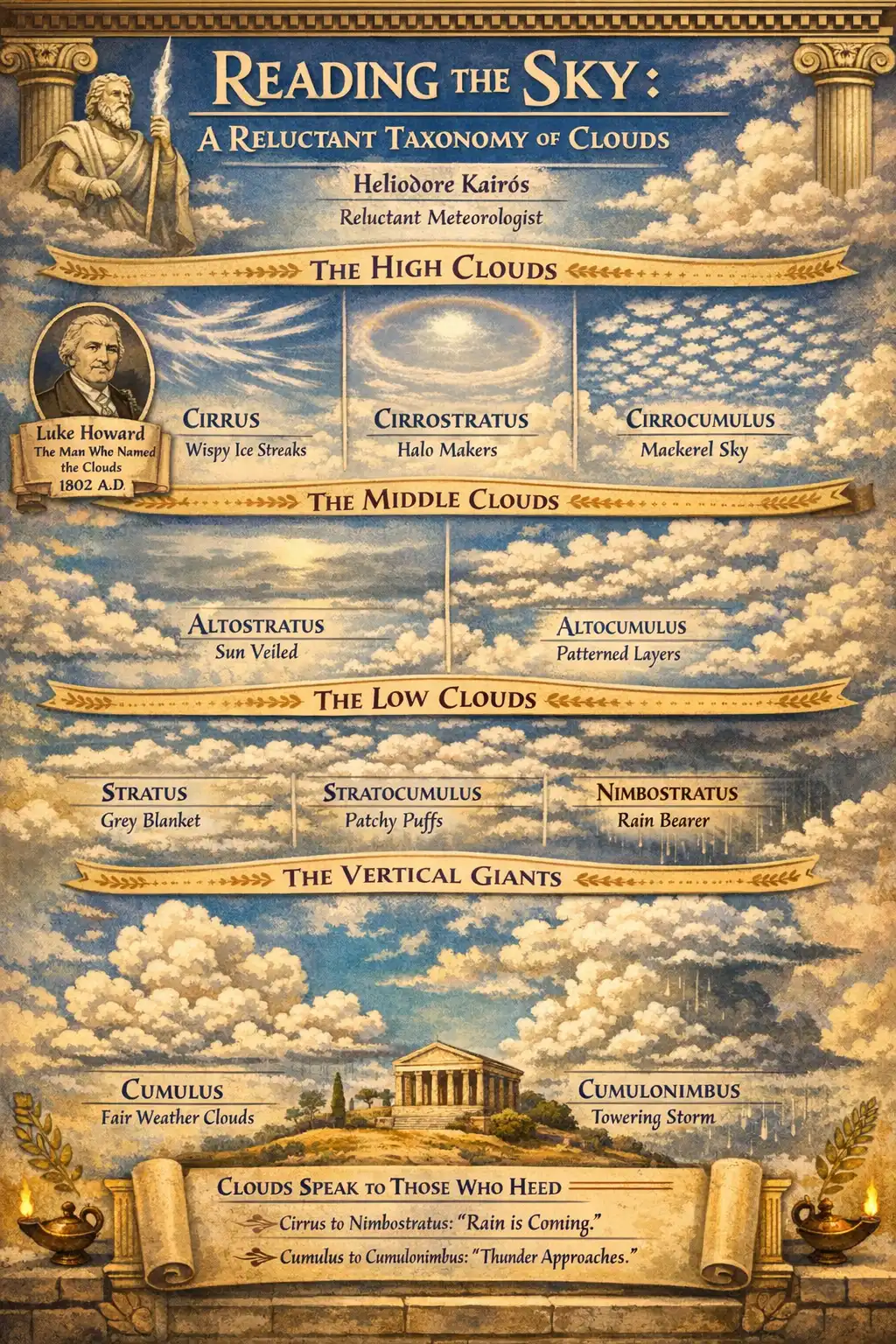
The High Clouds: Cirrus, Cirrostratus, Cirrocumulus
Let us begin at the top, where the air is thin, the temperature is savagely cold (typically minus 40 to minus 60 degrees Celsius), and water exists only as ice crystals. High clouds occupy altitudes above roughly 6,000 metres in temperate latitudes, though this floor shifts with geography and season.
Cirrus clouds are the delicate, wispy filaments that streak across an otherwise clear sky. They are composed entirely of ice crystals, often blown into hooks or commas by high-altitude winds that can exceed 200 kilometres per hour. The direction of the curl tells you which way the jet stream is blowing, if you care to notice. I always care to notice.
Isolated cirrus on an otherwise blue day generally indicates fair weather. But when cirrus begins to thicken and organize into parallel bands, converging toward a point on the horizon, you are watching a warm front announce itself, sometimes 24 to 48 hours before it arrives. The Weathered Pages contain no fewer than seventeen entries corroborating this pattern, each annotated with the barometric pressure at the time. I trust my notebook. The notebook has never smiled at a camera.
Cirrostratus is the veil. A thin, nearly transparent sheet of ice crystals that covers the sky and produces the characteristic halo around the sun or moon, a ring of light at exactly 22 degrees from the source, caused by refraction through hexagonal ice crystals. If you see a solar or lunar halo, rain is likely within 24 hours. This is not folklore. This is geometric optics meeting atmospheric dynamics. Nikolas Faros once called halos "a pretty optical effect." I will not elaborate on my reaction.
Cirrocumulus appears as small, white, regularly arranged patches or ripples, sometimes called a "mackerel sky" because it resembles fish scales. It is relatively rare and usually short-lived. Its presence suggests instability at high altitudes and, in some contexts, incoming turbulence. Pilots pay attention to cirrocumulus. Television presenters do not.
The Middle Clouds: Altostratus, Altocumulus
The prefix "alto" in cloud nomenclature means middle, roughly 2,000 to 6,000 metres, a zone where temperature hovers near the freezing point and clouds may contain both water droplets and ice crystals simultaneously.
Altostratus is the grey, featureless blanket that dims the sun without quite hiding it. You can still see the sun's position, but it appears watery, as though viewed through frosted glass. Altostratus is the opening act for serious precipitation. When it thickens and lowers, becoming opaque enough to hide the sun entirely, it is reclassified as nimbostratus. This transition often takes several hours, giving you ample warning to bring in the laundry. I have observed this process perhaps three hundred times. Each time, I note the moment of transition in The Weathered Pages with the same quiet satisfaction.
Altocumulus is more textured: rounded masses or rolls of white or grey, arranged in groups or lines or waves. It is one of the most visually varied genera, producing everything from the "sheep-back" sky (altocumulus lenticularis over mountains looks like stacked lenses, favoured by UFO enthusiasts) to the dramatic altocumulus castellanus, which sprouts turrets like a medieval fortress and signals afternoon thunderstorms. If you see castellanus in the morning, pack accordingly.
A useful test: if you hold your hand at arm's length and a single cloud element is roughly the size of your thumbnail, it is likely altocumulus. If it is the size of your fist, you are probably looking at stratocumulus, which belongs to the lower deck. This is the sort of practical knowledge that no app can replicate, though I am told they try.
The Low Clouds: Stratus, Stratocumulus, Nimbostratus
Below 2,000 metres, the atmosphere becomes denser, warmer, and considerably less elegant. Low clouds are the workhorses of the sky: thick, grey, frequently responsible for the drizzle that ruins Athenian hair and Parisian moods alike.
Stratus is the simplest cloud: a uniform, grey layer that blankets the sky like a damp sheet. It often forms overnight when a moist air mass cools below its dew point, and it can persist stubbornly through the morning. Stratus may produce drizzle or light snow, but nothing dramatic. It is the most boring cloud, and I say this with a certain tenderness. Not everything needs to be spectacular.
Stratocumulus is stratus with personality. It breaks into lumps, rolls, or patches, with visible gaps of blue between them. Stratocumulus covers more of the Earth's surface than any other cloud type at any given moment, roughly 23% of ocean surfaces and 12% of land. It plays an outsized role in Earth's energy balance because it reflects incoming solar radiation back to space while being too thin and warm to trap much outgoing longwave radiation. Climate modellers lose sleep over stratocumulus. So, for different reasons, does Nikolas Faros, who once described an overcast stratocumulus deck as "partly cloudy." I lit my pipe.
Nimbostratus is the rain cloud, properly speaking. Thick, dark, formless, occupying multiple atmospheric layers simultaneously, it produces sustained, moderate to heavy precipitation over wide areas. There is no sunlight visible through nimbostratus. There is no silver lining. There is only rain, and the satisfaction of having predicted it six hours ago when the cirrostratus appeared. This, I maintain, is the purest form of meteorological joy: being right, slowly, while getting wet.
The Vertical Giants: Cumulus and Cumulonimbus
Some clouds refuse to stay in their assigned layer. Cumulus and cumulonimbus are vertical developments, towers of convective energy that can span the entire troposphere.
Cumulus in its modest form (cumulus humilis) is the archetypical fair-weather cloud: flat base, cauliflower top, drifting lazily on a summer afternoon. It forms when the sun heats the ground, warm air rises in thermals, and water vapour condenses at the lifting condensation level. The flat base of a cumulus cloud marks exactly the altitude where the air temperature equals the dew point. Every cumulus cloud is a thermometer, if you know how to read it.
But cumulus grows. Cumulus mediocris develops moderate vertical extent. Cumulus congestus towers upward, its top beginning to lose its sharp cauliflower outline as ice crystals form. And then, if conditions permit (sufficient moisture, sufficient instability, sufficient wind shear), it becomes the monarch of all clouds.
Cumulonimbus is the thunderstorm engine. It can extend from a base at 500 metres to a top above 12,000 metres, sometimes punching into the stratosphere as an overshooting top. It produces lightning, hail, torrential rain, downbursts, and occasionally tornadoes. The characteristic anvil shape of a mature cumulonimbus (the flat, spreading top) forms when the ascending air hits the tropopause and can rise no further, spreading laterally like smoke hitting a ceiling.
A single large cumulonimbus can contain energy equivalent to ten Hiroshima-sized nuclear weapons. This is a verified estimate from NOAA, not one of my dramatic exaggerations. I am capable of dramatic exaggeration, but the atmosphere, in this case, needs no help.
What the Clouds Are Telling You
As Heraclitus once noted, though in a context that had nothing whatsoever to do with meteorology, everything flows. The sky is not static. Clouds are not ornaments. They are the visible expression of invisible processes: evaporation, condensation, convection, advection, subsidence. Each genus tells a story about temperature, humidity, and atmospheric stability at its altitude.
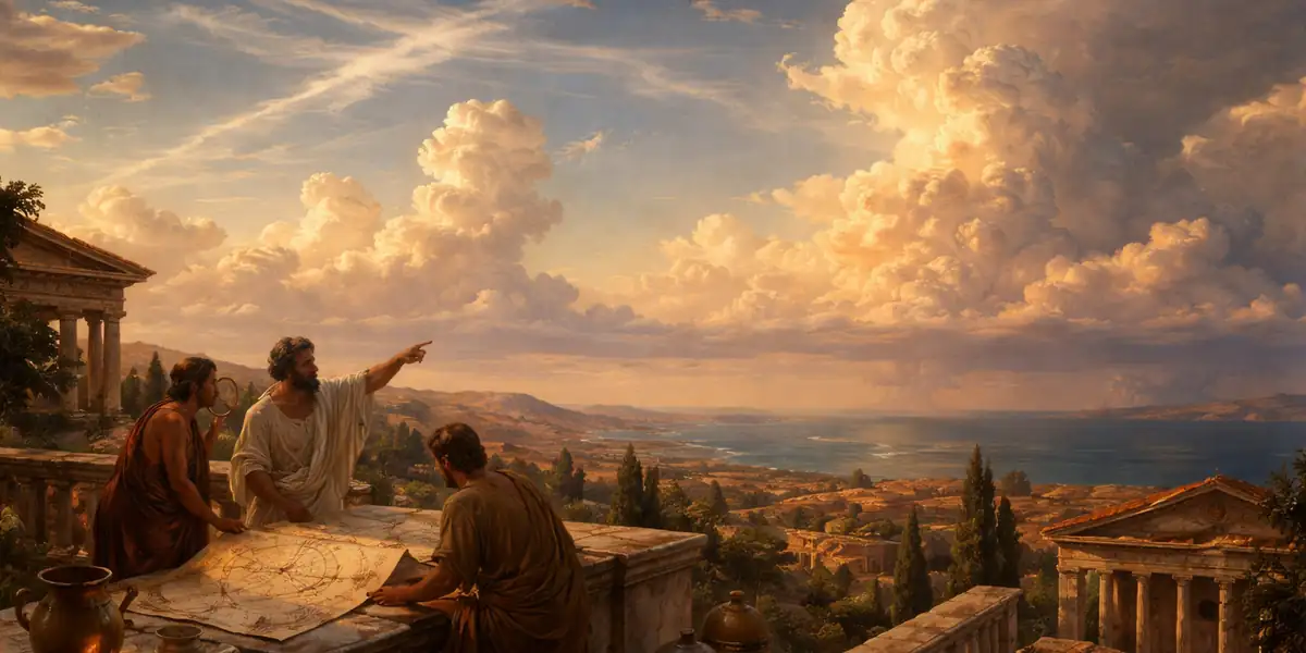
The sequence matters. Cirrus thickening into cirrostratus, followed by altostratus lowering into nimbostratus, is a classic warm front progression. You can read it like a sentence. The sky is saying: "Rain in twelve hours. Perhaps sooner." Isolated cumulus growing into congestus and then cumulonimbus is a different sentence: "Thunderstorm this afternoon. Find shelter."
For centuries before barometers and satellites, sailors, shepherds, and farmers read these sequences fluently. The old proverb "mackerel sky and mare's tails make tall ships carry short sails" is a genuine meteorological observation: cirrus uncinus (the mare's tails) and cirrocumulus (the mackerel pattern) together signal strong winds and approaching frontal weather. This is not superstition. It is pattern recognition developed over millennia, and it works.
Howard's Legacy, and a Grudging Concession
Luke Howard lived to the age of 92, long enough to see his classification system adopted internationally. He never stopped observing. He never stopped recording. The Meteorological Society of London elected him a fellow. Goethe kept his portrait. And yet, outside meteorological circles, Howard remains almost unknown. I find this unjust. A man who taught the world to read the sky deserves better than a Wikipedia page and a blue plaque in Tottenham.
He also, I must concede with visible discomfort, would likely have appreciated the cloud identification tools now available on certain outdoor watches and smartphone applications. These devices use barometric pressure, altitude, humidity, and GPS-referenced weather data to supplement what the human eye can observe. They cannot, of course, feel the shift in wind direction on their skin or smell the particular metallic note that precedes a thunderstorm. But for those who have not spent forty years on a Greek island, staring upward with a pipe and a notebook, they are, I suppose, a reasonable starting point.
I will not say they are better. I will say they exist, and that Luke Howard, the pharmacist who looked up when everyone else looked down, might have found them interesting.
My pipe, for the record, remains lit.