Thirty-One Satellites and a Greek Islander: How GPS Actually Works

There are, at this very moment, thirty-one satellites circling the Earth at an altitude of 20,200 kilometres. They do nothing but broadcast the time. This is, by any reasonable standard, an extravagant use of orbital real estate, and yet I must concede (while relighting my pipe, which tends to go out during moments of intellectual generosity) that without them, your hiking watch would be little more than an expensive bracelet with aspirations.
GPS Coordinate Converter
Enter coordinates, use geolocation, or switch to DMS mode.
What is the difference between Decimal and DMS?
Decimal degrees (e.g. 48.8566, 2.3522) use a single number with decimals. DMS (Degrees, Minutes, Seconds — e.g. 48° 51′ 23.76″ N) splits each coordinate into three parts. Both represent the same location; decimal is used by most apps and APIs, DMS by traditional maps and aviation.
What is UTM?
Universal Transverse Mercator divides the Earth into 60 zones and expresses positions in metres (easting and northing). It is widely used in military mapping, hiking, and surveying because distances can be measured directly in metres without spherical trigonometry.

I have never needed the Global Positioning System. My island is small enough that getting lost on it would require a deliberate and sustained effort, something I associate more with Nikolas Faros attempting to locate his own studio than with anyone possessing a functioning sense of direction. But the system itself, the engineering behind it, deserves a reluctant nod of respect. Possibly even two nods.
So let us talk about GPS. Not the simplified version Nikolas recites when his producer asks him to "explain the weather tech" during sweeps week, but the actual thing: atomic clocks in orbit, corrections for the curvature of spacetime, and a mathematical trick called trilateration that your wrist computer solves several times per second without once asking for your permission.
As Heraclitus once noted, though in a context that had absolutely nothing to do with satellite navigation, "The way up and the way down are one and the same." I find this oddly appropriate. The signals go down. The math goes up. And somewhere in between, a small device on your arm decides where you are.
A Constellation of Clocks
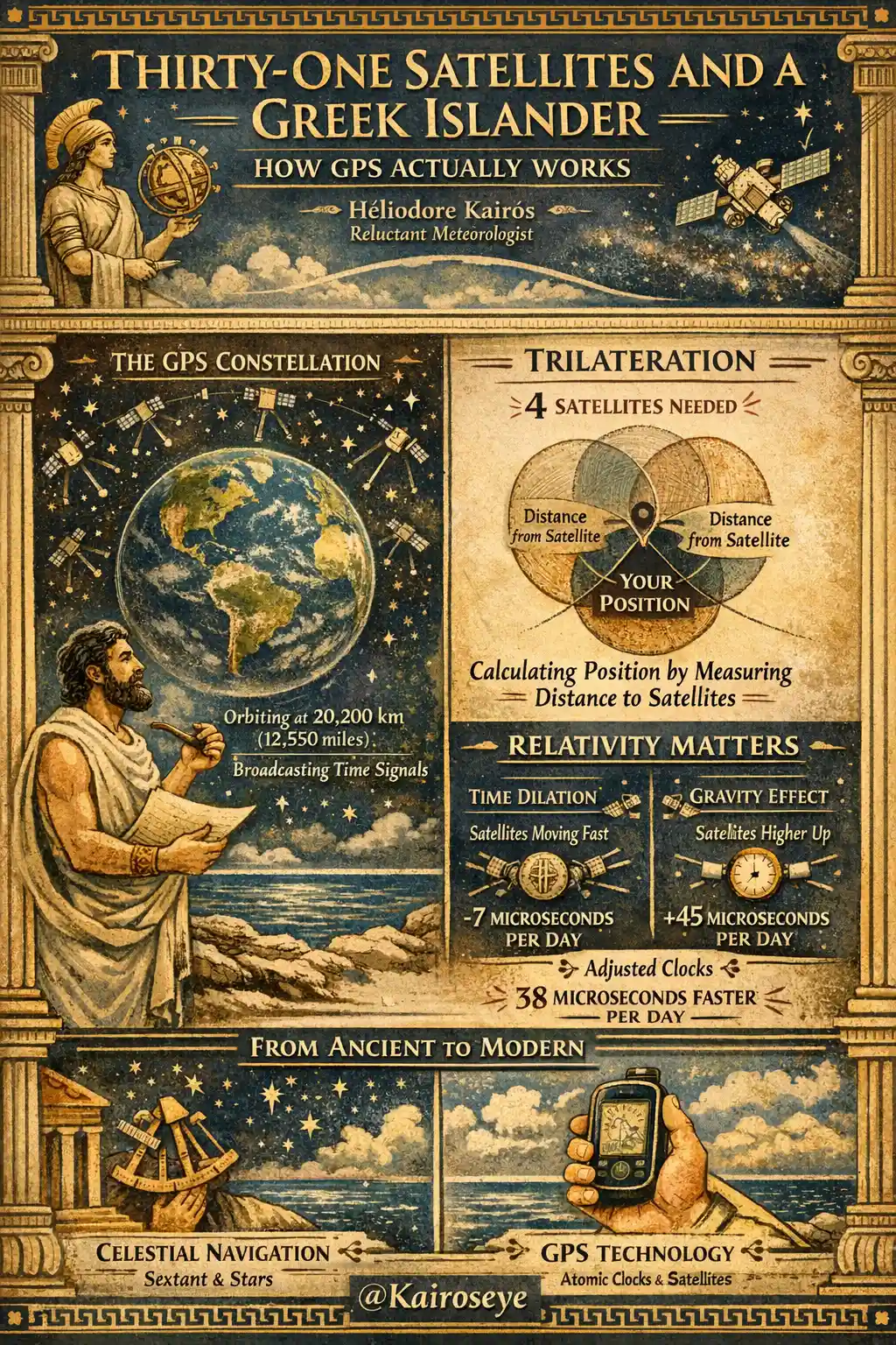
The GPS constellation is maintained by the United States Space Force (a name I still cannot say without a slight twitch of the eyebrow). It consists of thirty-one operational satellites distributed across six orbital planes, each inclined at 55 degrees to the equator. Every satellite completes one orbit in approximately 11 hours and 58 minutes, which means each one circles the Earth exactly twice per sidereal day. This is not a coincidence. It is orbital choreography, arranged so that at any given moment, from any point on Earth's surface, at least four satellites are visible above the horizon.
Four. Remember that number. It will matter shortly.
Each satellite weighs between 1,100 and 2,200 kilograms, depending on which generation (or "block," as the engineers insist on calling it) we are discussing. They orbit at 20,200 kilometres, comfortably above the weather, above the International Space Station, above everything your airline pilot has ever worried about. At that altitude, they are in what is called medium Earth orbit, a region of space that is neither close enough to be convenient nor far enough to be romantic. It is the suburban commuter belt of orbital mechanics.
And what do these thirty-one suburban commuters do all day? They broadcast. Continuously. Each satellite transmits a signal containing two pieces of information: who it is, and what time it is. That is all. No weather data, no maps, no opinions about your route choices. Just an identification code and a timestamp, transmitted on multiple frequencies (L1 at 1575.42 MHz, L5 at 1176.45 MHz, among others) at the speed of light.
The signal itself travels at 299,792 kilometres per second. By the time it reaches your wrist, approximately 67 milliseconds have passed. The satellite has moved. The Earth has rotated. You have, in all likelihood, taken half a step. And your watch, that small vulgar device you insist on wearing, has already begun calculating.
The Most Expensive Clocks Ever Built
The entire GPS system rests on one premise: that we can measure time with absurd precision. Each satellite carries multiple atomic clocks, both cesium and rubidium, accurate to within one nanosecond per day. One nanosecond. That is one billionth of a second. In the time it took you to read that last sentence, approximately 800 million nanoseconds elapsed. They passed without ceremony.
Why does this precision matter? Because GPS is, at its core, a time-measuring system masquerading as a position-measuring system. Your receiver does not know where you are. It knows how long each satellite's signal took to arrive, and since those signals travel at the speed of light (a known and unwavering velocity), it can calculate the distance to each satellite. A one-microsecond error in timing translates to a 300-metre error in position. A one-nanosecond error translates to 30 centimetres. The difference between "you are on the trail" and "you are in the ravine" comes down to the quality of the clock.
According to The Weathered Pages, entry dated some Thursday in November 2019, I recorded that "the fishermen know the time by the angle of the sun, and they have not yet fallen into a ravine." This remains technically true. But I will admit, under protest, that their method does not scale well to mountain rescue operations.
The ground segment, consisting of five major control stations and sixteen monitoring stations scattered across the globe, continuously checks and corrects these clocks. When a satellite's clock drifts by as little as a few nanoseconds, correction data is uploaded. The system is obsessive about time in a way I find both admirable and slightly neurotic.
Trilateration, or the Art of Finding Yourself Without Asking for Directions
Here is where the geometry becomes beautiful, though I would never use that word in front of Nikolas Faros, who would somehow turn it into a segment about beach weather.
Your GPS receiver picks up signals from multiple satellites simultaneously. From each signal, it calculates a distance: signal travel time multiplied by the speed of light. One satellite gives you a sphere of possible positions. You are somewhere on the surface of a sphere with that satellite at the centre, its radius equal to the calculated distance. Two satellites narrow this to a circle where two spheres intersect. Three satellites reduce the possibilities to two points, one of which is usually somewhere absurd (deep inside the Earth, or far out in space), and the receiver discards it. Three satellites, then, should be enough.
But they are not. This is where the fourth satellite earns its place.
Your watch does not carry a cesium atomic clock. If it did, it would cost approximately $50,000 and weigh considerably more than your wrist would tolerate. Its internal clock is a cheap quartz oscillator, good enough for telling you it is 14:37, but not nearly good enough for measuring nanosecond-precision signal delays. The fourth satellite signal allows your receiver to solve for its own clock error as an additional unknown. Four satellites, four unknowns: latitude, longitude, altitude, and time correction.
The equations are solved through a process that would have given Pythagoras a headache and Euclid a quiet satisfaction. Your watch performs this computation several times per second. It does so silently, without complaint, and without any appreciation for the elegance of what it has just accomplished. I find this mildly offensive.
In practice, modern receivers often track eight to twelve satellites simultaneously, using the redundant signals to improve accuracy through a least-squares adjustment. The result: a position fix accurate to within three to five metres under open sky. In dense forest or urban canyons, somewhat worse. On my terrace, overlooking the Aegean, excellent.
Einstein Was Right (Unfortunately)
This is the part of the story that I find most deeply satisfying, because it proves that pure theoretical physics (the kind done with chalk and thought experiments rather than satellite uplinks) is not merely decorative.
The atomic clocks on GPS satellites do not tick at the same rate as identical clocks on Earth's surface. There are two competing effects, both predicted by Einstein's theories of relativity, and both measurable enough to ruin your position fix if ignored.
First, special relativity. The satellites move at approximately 3.9 kilometres per second relative to observers on the ground. At this velocity, time dilation causes the onboard clocks to run slower by about 7 microseconds per day. This is the famous "moving clocks run slow" effect. It is small, but it is real, and if you think 7 microseconds is negligible, recall that one microsecond of timing error equals 300 metres of position error.
Second, general relativity. The satellites orbit at 20,200 kilometres, where Earth's gravitational field is weaker than at the surface. Clocks in weaker gravity run faster. This effect adds approximately 45 microseconds per day.
The two effects work in opposite directions. The net result: satellite clocks run faster than ground clocks by roughly 38 microseconds per day. Left uncorrected, this would introduce a positional error of approximately 11 kilometres per day. By the end of a week, your hiking watch would place you in a different country. By the end of a month, a different continent.
The engineers solved this with characteristic elegance. Before launch, the atomic clocks are deliberately set to tick slightly slower than their nominal frequency: 10.22999999543 MHz instead of 10.23 MHz. This pre-correction accounts for the relativistic offset. Additional fine-tuning is applied in real time by the ground control segment.
Heraclitus, I suspect, would have appreciated this. Everything flows, yes, but with a carefully calibrated offset. Even time, that most fundamental of rivers, runs at different speeds depending on where you stand and how fast you are moving. Nikolas Faros announced something about "satellite accuracy" last autumn with his usual confidence. He did not mention Einstein. He never does.
From Military Secret to Hiking Companion
GPS began, as so many useful things do, as a military project. The first experimental satellite, Navstar 1, launched in February 1978. The system achieved full operational capability in 1995, with a constellation of 24 satellites. It was designed for the United States Department of Defense, and for its first decade of civilian availability, the military deliberately degraded the signal through a policy called Selective Availability, introducing intentional errors of up to 100 metres.
On May 1, 2000, President Clinton ordered Selective Availability turned off. Overnight, civilian GPS accuracy improved from approximately 100 metres to roughly 10 metres. Today, with modern dual-frequency receivers and augmentation systems such as WAAS and EGNOS, accuracy for consumer devices sits comfortably at three to five metres.
Other nations, noting the strategic advantage of controlling a global navigation system, built their own. Russia operates GLONASS with 24 satellites. The European Union built Galileo with 28 satellites. China deployed BeiDou with over 40 satellites. Your modern hiking watch, if it is anything worth wearing (a phrase I use loosely), receives signals from multiple constellations simultaneously, solving its position using perhaps forty or fifty satellites at once. This is redundancy on a scale that would make any ancient Greek engineer weep with admiration.
Celestial Navigation, the Original GPS
Before there were thirty-one satellites, there were the stars. Polynesian navigators crossed the Pacific using wave patterns, star positions, and the flight paths of birds. The Greeks used Polaris and the constellations to orient themselves across the Mediterranean. Hipparchus of Nicaea, working in the second century BCE, catalogued the positions of some 850 stars and essentially invented the coordinate system that celestial navigation depends upon.
The principle is not so different from GPS, if you squint. A navigator measures the angle between a celestial body and the horizon. From this angle and the known position of the star (published in an ephemeris, or in my case, scrawled in The Weathered Pages), the navigator calculates a line of position. Two stars give two lines. Where they cross: that is where you are. Three stars give you confidence. It is trilateration's older, slower, more dignified ancestor.
The difference, of course, is speed. A skilled celestial navigator needs perhaps twenty minutes with a sextant and reduction tables to produce a fix accurate to within a nautical mile. Your watch needs 67 milliseconds and produces a fix accurate to within three metres. I am not saying one is better than the other. I am saying one requires knowledge, and the other requires a charged battery. These are different things, and I will thank you not to confuse them.
A Reluctant Admission
I have spent the better part of this article explaining a system I did not ask for, do not need, and find philosophically suspicious. Thirty-one satellites, each carrying clocks more precise than anything Hipparchus could have imagined, orbiting at 20,200 kilometres, corrected for effects predicted by Einstein, broadcasting timestamps that your wrist computer transforms into a position fix several times per second.
It is, I will admit this once and once only, rather good engineering.
The fact that a modern hiking watch can display your latitude, longitude, altitude, bearing, and estimated time of arrival, all derived from signals that have travelled 20,200 kilometres at the speed of light and been corrected for the curvature of spacetime, is not nothing. It is, if I am being honest (and the pipe smoke tends to encourage honesty in the late afternoon), one of the more remarkable achievements of the species.
I still prefer The Weathered Pages. I still believe that knowing your landscape is superior to knowing your coordinates. But when the fog rolls in over the ridge and the trail markers vanish, when Nikolas Faros is safe in his air-conditioned studio and you are decidedly not, there is something to be said for a small device that knows, to within three metres, exactly where you stand.
Even if it is, undeniably, a watch.