When the Sky Loses Its Temper: Storms, Tornadoes, Cyclones and Blizzards

I was sitting on the terrace last Thursday, pipe lit, coffee lukewarm, watching a perfectly unremarkable cumulus drift over the Aegean. Harmless. Decorative, even. The kind of cloud Nikolas Faros would point at with his manicured index finger and call "partly cloudy, temperatures mild." And he would be right, technically, which is the most irritating kind of right.
But that same cumulus, given the proper atmospheric indignities, the right combination of heat, moisture, and shear, could have become something far less decorative. It could have grown twelve kilometres tall, spawned hail the size of walnuts, and rearranged the furniture of an entire village. The atmosphere, you see, has a temper. Most days it keeps it in check. Some days it does not.
This is an article about those days.
The Anatomy of a Tantrum
Every violent weather event begins with the same unglamorous ingredient: instability. Warm air near the surface, cooler air above, and enough moisture to fuel the engine. The atmosphere, in its resting state, is stratified, layered like a reasonably competent baklava. When that stratification breaks down, when the warm layer at the bottom becomes too warm, too humid, too impatient, it punches upward through the cooler air above with startling conviction.
This is convection. It is also, in principle, what happens when you heat soup. The difference is that atmospheric convection can accelerate air parcels to vertical speeds exceeding 50 metres per second and produce electrical discharges carrying 300 million volts. Your soup does neither of these things.
The measure of this instability is something meteorologists call CAPE, Convective Available Potential Energy, expressed in joules per kilogram. A CAPE value below 1,000 J/kg is modest. Above 2,500 J/kg, you should probably close your shutters. Above 5,000 J/kg, the atmosphere has essentially decided to redecorate, and your opinion on the matter is not being solicited.
From Cloud to Cumulonimbus: The Thunderstorm
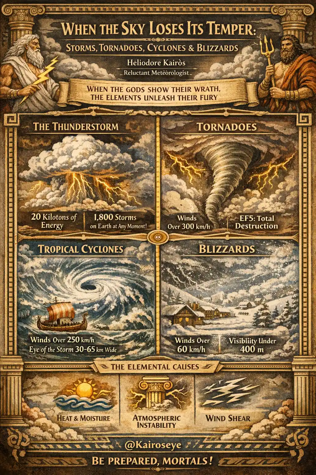
The ordinary thunderstorm is the common ancestor of nearly all violent weather. It begins as a cumulus cloud, grows through vigorous updrafts into a cumulonimbus, and reaches maturity when the updraft is joined by a downdraft. The entire lifecycle, from first wisp to final raindrop, takes roughly 30 to 60 minutes. It is brief, noisy, and occasionally destructive, not unlike a departmental faculty meeting.
A single mature thunderstorm cell releases energy equivalent to roughly 20 kilotons of TNT, comparable to the Hiroshima bomb. The atmosphere does this several thousand times a day across the globe. At any given moment, there are approximately 1,800 thunderstorms in progress on Earth. Nikolas Faros covers perhaps two of them per broadcast.
What separates a garden-variety thunderstorm from something genuinely dangerous is organisation. An isolated cell dissipates quickly because its own rain-cooled downdraft chokes the updraft that feeds it. The storm, in essence, kills itself. But when wind shear is present, when wind speed or direction changes with altitude, the updraft and downdraft become separated. The storm can breathe. It can persist. And persistence, in atmospheric terms, is where things get properly unpleasant.
The Supercell: Architecture of Violence
The supercell thunderstorm is the aristocrat of convective systems. It is a single, rotating updraft, called a mesocyclone, that can sustain itself for hours. The rotation comes from wind shear: winds at the surface blow from one direction, winds aloft from another, creating a horizontal tube of spinning air. The storm's updraft tilts this tube vertical. Now you have a rotating column of air embedded within a thunderstorm, and the atmosphere's temper has moved from irritation to genuine fury.
Supercells produce the largest hail (up to 15 centimetres in diameter, recorded in Vivian, South Dakota, in 2010), the most intense rainfall, and, crucially, most of the world's significant tornadoes.
I note this with a certain reluctance. I have always preferred phenomena that can be observed from a safe distance with a glass of wine. Supercells do not accommodate this preference.
Tornadoes: When the Sky Reaches Down
A tornado is a violently rotating column of air extending from the base of a thunderstorm to the ground. The definition is deceptively simple. The reality is a funnel of wind that can exceed 480 km/h (in the case of the 1999 Bridge Creek, Oklahoma tornado, where mobile Doppler radar measured winds at approximately 484 km/h, the highest ever reliably recorded on Earth).
The Enhanced Fujita Scale, adopted in the United States in 2007, classifies tornadoes from EF0 (minor damage, winds 105-137 km/h) to EF5 (total destruction, winds exceeding 322 km/h). An EF5 tornado can strip asphalt from roads, deform steel-reinforced concrete, and hurl automobiles hundreds of metres. The atmosphere, it must be said, does not do things by halves.
The formation process remains, even now, incompletely understood. We know the ingredients: a supercell, strong wind shear, a rear-flank downdraft that wraps around the mesocyclone and tightens the rotation through conservation of angular momentum, the same principle that makes a figure skater spin faster when pulling in their arms. But why some supercells produce tornadoes and others do not, with seemingly identical atmospheric profiles, remains one of meteorology's persistent embarrassments.
According to The Weathered Pages, entry dated a particularly windy April in 2004, I once observed a wall cloud rotating with unmistakable intent over the southern Aegean. Nothing came of it. The atmosphere, like a tenured professor, reserves the right to threaten without following through.
The United States records approximately 1,200 tornadoes per year, more than any other country, largely due to the collision of warm, moist Gulf air with cold Canadian air masses over the flat terrain of the Great Plains. But tornadoes occur on every continent except Antarctica. Europe sees roughly 300 per year, many of them waterspouts over the Mediterranean. I have seen several. They are, I will concede, magnificent, provided they remain over water and away from my terrace.
Tropical Cyclones: The Heat Engine
If a tornado is a stiletto, a tropical cyclone is a siege. The two phenomena could hardly be more different in scale. A large tornado might be two kilometres wide. A tropical cyclone can span 1,000 kilometres. Typhoon Tip, in 1979, measured 2,220 kilometres in diameter, roughly the distance from Athens to London. The Weathered Pages contain no entry for Typhoon Tip, because I was, at the time, wisely elsewhere.
The tropical cyclone is a heat engine. It feeds on warm ocean water, requiring a sea surface temperature of at least 26.5°C to form. Evaporation from the ocean surface provides the moisture; condensation of that moisture at altitude releases the latent heat that drives the system. The Coriolis effect, the deflection caused by Earth's rotation, gives the system its characteristic spin: counterclockwise in the Northern Hemisphere, clockwise in the Southern. This is why tropical cyclones do not form within roughly five degrees of the equator, where the Coriolis effect is too weak to initiate rotation.
The terminology is geographical, not meteorological. A hurricane, a typhoon, and a cyclone are the same phenomenon. In the Atlantic and northeast Pacific, we say hurricane. In the northwest Pacific, typhoon. In the South Pacific and Indian Ocean, tropical cyclone or simply cyclone. The Saffir-Simpson scale classifies hurricanes from Category 1 (sustained winds 119-153 km/h) to Category 5 (sustained winds exceeding 252 km/h).
The eye of the cyclone, that eerie circle of calm at the centre, typically measures 30 to 65 kilometres across. Winds in the eyewall, the ring of thunderstorms surrounding the eye, are the most intense. Hurricane Patricia in 2015 produced sustained winds of 345 km/h, the highest reliably measured in a tropical cyclone.
What fascinates me, reluctantly, is the energy budget. A mature hurricane releases heat energy at a rate of approximately 6 × 10^14 watts, equivalent to roughly 200 times the entire world's electrical generating capacity. Every day, a single hurricane releases the energy equivalent of about 10,000 nuclear weapons. The atmosphere, it turns out, is not subtle.
Nikolas Faros once referred to a Category 1 hurricane as "a bit of wind." My pipe nearly went out from the force of my sigh.
Blizzards: The Cold Fury
We have discussed heat. Let us now discuss its absence.
A blizzard is not merely heavy snowfall. The US National Weather Service defines a blizzard as sustained winds or frequent gusts of 56 km/h or more, with falling or blowing snow that reduces visibility to less than 400 metres, persisting for at least three hours. The snow itself may already be on the ground; the wind simply picks it up and weaponises it.
The physics here is different from convective storms. Blizzards are typically associated with extratropical cyclones, large-scale low-pressure systems that form along frontal boundaries where cold polar air collides with warmer mid-latitude air. These are not heat engines like tropical cyclones; they draw their energy from the temperature contrast between the air masses, a mechanism called baroclinic instability.
The Great Blizzard of 1888 buried the northeastern United States under drifts exceeding 15 metres in places, killed more than 400 people, and paralysed New York City for days. It was this storm, more than any other, that convinced city planners to move telegraph and power lines underground and to build the New York subway system. Infrastructure, it seems, learns from humiliation.
Wind chill is the blizzard's particular cruelty. At an air temperature of -20°C with winds of 60 km/h, exposed skin experiences conditions equivalent to roughly -36°C. Frostbite can begin within ten minutes. The atmosphere, having lost its temper, now intends to keep it lost for quite some time.
The Derecho: The Forgotten Cousin
I include the derecho because it deserves better than obscurity. A derecho (from the Spanish for "straight," as opposed to "tornado," which is twisted) is a widespread, long-lived windstorm associated with a fast-moving band of severe thunderstorms called a bow echo. To qualify, the swath of wind damage must extend at least 400 kilometres, with gusts of 93 km/h or greater along most of its length.
The June 2012 derecho that swept from Iowa to the Atlantic coast produced winds exceeding 130 km/h, left 4.2 million people without power, and killed 22 people. It covered 1,000 kilometres in roughly 10 hours. And yet most people have never heard the word "derecho." I suspect Nikolas Faros is among them.
Poseidon, Aeolus, and the Mythology of Rage
The ancient Greeks, who lived beneath the same unstable atmosphere I observe daily from my terrace, understood violent weather as divine mood. Poseidon shook the seas; Zeus hurled thunderbolts; Aeolus, keeper of the winds, released them from his leather bag with varying degrees of carelessness.
Theophrastus, student of Aristotle and author of the earliest known treatise on weather signs (De Signis Tempestatum, circa 300 BCE), catalogued observable precursors to storms: the behaviour of animals, the colour of the sky at sunset, the feel of the air on skin. Many of his observations hold up remarkably well. "A halo around the moon means rain within three days" has a reasonable physical basis; the halo is caused by ice crystals in cirrostratus clouds that often precede a warm front.
I find Theophrastus a more reliable forecaster than several modern television presenters. He at least looked at the sky.
Why It Matters Now
The relationship between climate change and violent weather is not a matter of "more storms." It is a matter of fuel. A warmer atmosphere holds more moisture, roughly 7% more water vapour per degree Celsius of warming (the Clausius-Clapeyron relation). More moisture means more latent heat available for convection, heavier precipitation, and, in the case of tropical cyclones, a higher energy ceiling.
Research published by NOAA indicates that while the total number of tropical cyclones globally has not clearly increased, the proportion of storms reaching Category 4 or 5 intensity has risen significantly since the 1980s. The storms are not more frequent; they are more intense. This is, as Heraclitus might have noted though in an entirely different context, a distinction that matters enormously.
A Reluctant Concession
I have spent forty years watching the sky with my own eyes, recording barometric pressure in The Weathered Pages, and noting the behaviour of swallows before a front arrives. I will continue to do so.
But I will also concede, with the enthusiasm of a man swallowing medicine, that a device on one's wrist capable of displaying real-time barometric pressure, storm alerts, wind speed, and GPS coordinates has a certain... utility. When the sky loses its temper, knowing exactly where you stand, both geographically and barometrically, is not nothing.
The KairosEye watch face displays this data. I find the font size too small, the interface unnecessarily cheerful, and the entire concept philosophically suspect. But when a supercell is bearing down on your position, philosophy makes a poor umbrella.
Nikolas Faros, I am told, does not wear a watch at all. He reads the teleprompter. The teleprompter, alas, has never once detected a mesocyclone.